
On the implementation of the "National Spatial Data Infrastructure" project
09.02.2025 13:56:57 8457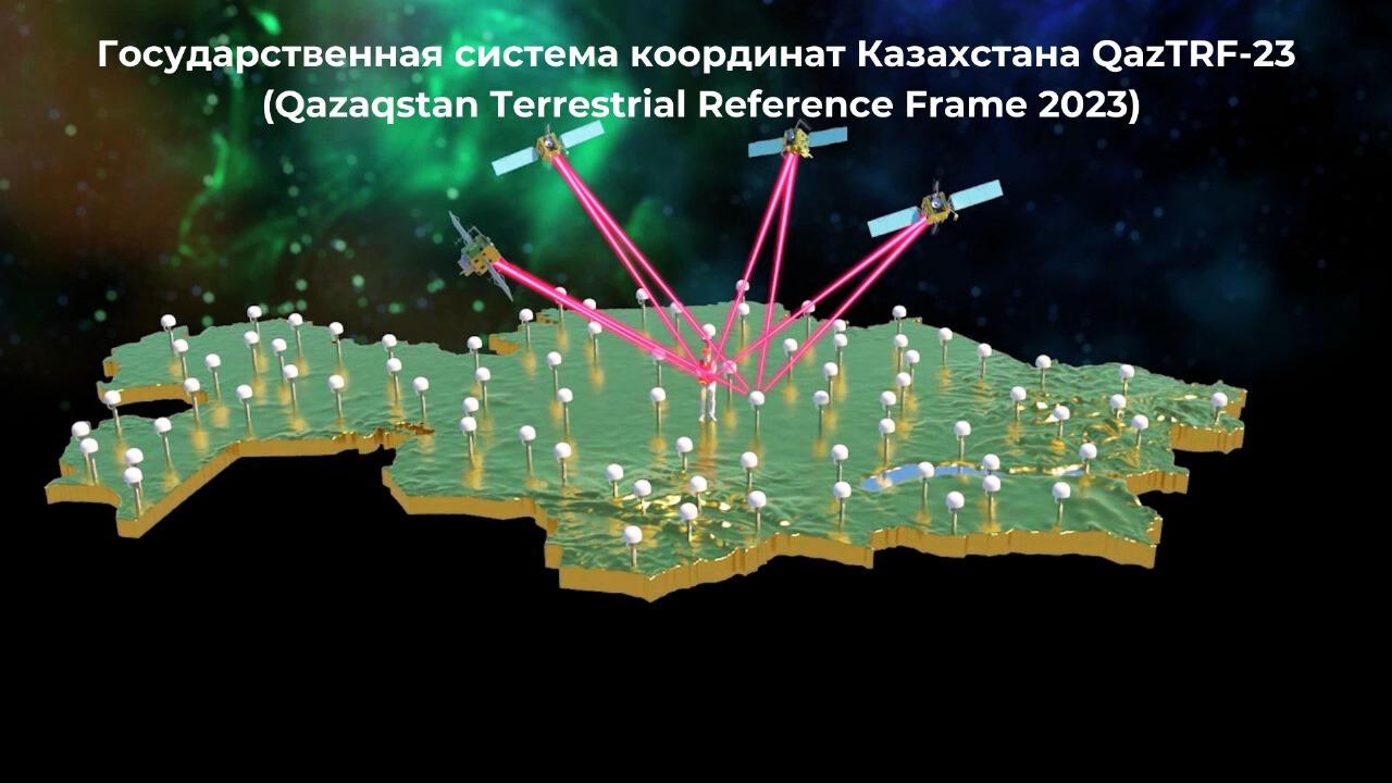
The Ministry of Digital Development, Innovations and Aerospace Industry of the Republic of Kazakhstan has completed the implementation of the "National Spatial Data Infrastructure" (NSDI) project.
NSDI is an important step in the development of the digital economy, geospatial services and innovative technologies such as GIS, BIM, Smart City, unmanned vehicles, VR/AR, precision agriculture.
As part of the project, significant results were achieved in the field of geodesy, cartography and digital transformation of spatial data.
Main achievements of the project:
The state geodetic, leveling and gravimetric networks were modernized.
A modern state coordinate system - QazTRF-23 (Qazaqstan Terrestrial Reference Frame 2023, the Kazakhstani land coordinate calculation base for 2023) was introduced. This system was supported by a network of permanently operating reference stations CORS (instead of the 1942 coordinate system).
Transformation parameters (recalculation keys, deformation matrix) between coordinate systems were developed.
A Unified Digital Cartographic Base (UDCG) was created based on QazTRF-23, which includes:
Maps of the territory of the republic at scales of 1:25,000, 1:100,000.
Plans of cities and district centers at scales of 1:2,000.
A Unified Orthophotomosaic was created based on QazTRF-23, which includes:
Aerospace survey materials of the territory of the republic at scales of 1:25,000.
Aerophotograph materials of cities and district centers at scales of 1:2000.
Information system "State Geodetic Support" (ggo.gov.kz) was created, which provides CORS network management, automation of QazTRF-23 distribution and services, processes of connecting permanent reference stations to the state geodetic network, feedback on the status of geodetic points. Provides GNSS receivers with the necessary information for correcting coordinates in real time (RTK). Also, the system publishes a catalog of coordinates of geodetic points in QazTRF-23.
The information system "State Geoportal of the National Geodetic Survey of the Republic of Kazakhstan" (map.gov.kz) was created and put into industrial use. This is a unique digital cartographic platform, where the BCKN, a single orthophotomosaic of the entire territory of the republic, cities and district centers is published, and the platform also includes links to spatial data of central and local government bodies (borders of administrative-territorial units, SQAZ, transport infrastructure, etc.), information systems, geoportals, geoservices and their metadata. In the "NCDI State Geoportal" IS, users can collect various data and conduct complex analysis using the "Create Your Own Map" tool.
All cartographic materials and spatial data are published on the NCDI State Geoportal and are available in digital format.
The online cartographic service allows you to download NCDI cartographic materials, thereby creating an environment for Kazakhstani startups, cartographic and IT companies to develop services such as Google Maps, Yandex Taxi, 2GAZ directory and offer them to businesses and citizens.
Source : https://www.gov.kz/memleket/entities/mdai/press/news/details/929954